| 
| Located in Village Square in front of the Village Office Building MARKER TEXT
Established in 1851 after the addition of the Cincinnati, Hamilton, and Dayton Railway, Glendale incorporated in 1855 as Ohio's first planned community and one of the nation's first planned villages. The original planning included forested greenbelts and parks, curvilinear streets meandering around established trees, large lots, and superior building standards. Glendale is designated as a National Historic Landmark community from the Department of Interior and a Certified Local Government through the Ohio Historic Preservation Office, all owed to Glendale's persistent adherence to the plan and faithful preservation of original infrastructure. Much of today's preserved infrastructure includes the original 59 pivotal buildings, curvilinear streets, tree canopy, stone gutters, gas streetlights, and railroad depot. 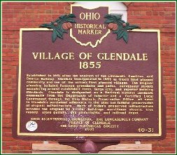 Click Picture to Enlarge |
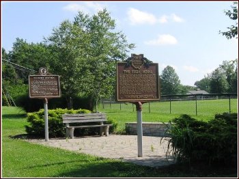
New Marker Display Pavilion The new pavilion is a joint venture between Glendale, Evendale, and Woodlawn, and is located on Oak Road at Chester Road. | ||
Located at the intersection of Oak and Chester MARKER TEXT
Three hundred yards east of this location on Oak Road, overlooking the Miami & Erie Canal, was the house of abolitionist John Van Zandt (1791-1847). For years this house was known as one of the most active "stations" on the Underground Railroad. In 1842, two bounty hunters from Sharonville caught Van Zandt helping eight runaway slaves who had escaped from owner Wharton Jones of Kentucky. Defended in court by Salmon P. Chase, who became Chief Justice of the Supreme Court of the United States from 1864-1873, Van Zandt was convicted and fined. Chase appealed the case to the U.S. Supreme Court, where he tested the constitutionality of the 1793 Fugitive Slave Law. When writing her novel Uncle Tom's Cabin, Harriet Beecher Stowe used Van Zandt as the abolitionist character John Van Trompe. Van Zandt's house became associated with the book and was known as "The Eliza House," named for one of the novel's main characters. 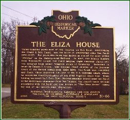 Click Picture to Enlarge | Located at the intersection of Oak and Chester MARKER TEXT
In the year 1792, Henry Tucker started clearing land and erecting a Station House on the old Indian Trace in what is now the Village of Woodlawn. He had purchased the land from John Cleves Symmes for two dollars per acre. Fear of Indian attack drove the pioneers back to Columbia where they remained until General Anthony Wayne started his march north to engage the Indians in battle.
Henry and Mary Tucker returned to this farm in 1794. The Station House was completed and was to be used as a fort in case of Indian attack. Worship services were conducted in the Station House and later in neighboring cabins. The result was the organization of The Springfield Baptist Church in 1798, now known as Landmark Baptist Temple. The Tuckers are buried not far from this point in the rich soil from which they helped carve an empire. This marker is erected to the memory of Henry and Mary Tucker who were among the first settlers of Ohio. Historical Committee - Landmark Baptist Temple 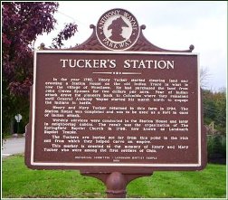 Click Picture to Enlarge | |
Located at the intersection of Springfield Pike and Congress Avenue Unveiled on October 28, 2006 MARKER TEXT
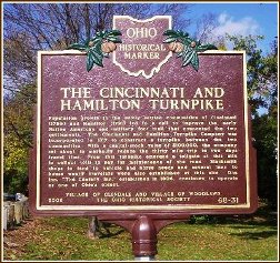
Population growth in the newly settled communities of Cincinnati (1788) and Hamilton (1791) led to a call to improve the early Native American and military foot trail that connected the two settlements. The Cincinnati and Hamilton Turnpike Company was incorporated in 1817 to construct a turnpike between the two communities. With a capital-stock value of $100,000, the company set about to markedly reduce the thirty mile trip to two days travel time. From this turnpike emerged a tollgate at this site to collect tolls to pay for maintenance of the road. Blacksmith shops to tend to vehicle and horse needs and several inns to house weary travelers were also established at this site. One inn, The Century Inn, established in 1806, continues to operate as one of Ohio's oldest.
 Click Picture to Enlarge | Located at 42 Washington Avenue Unveiled on May 29, 2011 MARKER TEXT
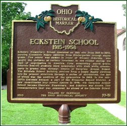
Eckstein Elementary School operated on this site from 1915 to 1958, serving Glendale?s Negro children from Kindergarten through eighth grade. The school was named in honor of Eleanor Eckstein, who taught the children at various locations in the village during the time of segregation in America. Upon completing eighth grade, Eckstein School?s students were integrated with their white counterparts in grades nine through twelve at Congress Avenue School. The Eckstein School building evolved from a single family dwelling into its present structure through a series of expansions, the last of which was the addition of the gymnasium in 1928. In the mid-1950s Glendale became a part of the Princeton School District. A new consolidated high school opened in 1958, the Congress Avenue School became Glendale Elementary, and Eckstein was closed. This commemorative text was composed by alumni of the Eckstein School.
 Click Picture to Enlarge 
| |
Located in Village Square Unveiled on July 13, 2013 
| 
| |
 Click Above Text to View Marker | ||